United States
US HISTORY:
America's initial Stone Age inhabitants arrived here by traversing the Bering Strait. During the following centuries, a wide variety of Indian cultures developed and prospered across the land.
After Columbus made his initial voyage to this New World, word of its potential riches spread across Europe, and explorers and settlers by the thousands soon stepped ashore along the Atlantic Ocean coastline.
In 1620, the Pilgrims arrived on the Mayflower, landing in what is modern-day Massachusetts; their settlement named Plymouth survived, and the story of a new nation was subsequently born.
One century later Britain's upstart colonies broke from England and declared their new-found independence during the Revolutionary War.
The new country of America expanded rapidly, well beyond the reach of the original 13 colonies, and inevitable conflicts and wars over lands rightfully claimed by Native Americans was the result. Indigenous Indians (Native Americans) were stripped of most of their lands and moved to reservations; the central plains were purchased from Napoleon (France); Florida was grabbed from Spain, and the entire southwest (including California) was annexed after a successful war with Mexico. The growing influence and size of the United States of America began to take shape.
A few more important facts regarding Native Americans, who were first conquered and displaced by overwhelming military power: as English expansion westward continued, it justifiably experienced wide-spread Amerindian resistance to their new settlements. In the end, many historical experts believe that among the various contributing factors to the ultimate demise of early Native Americans, epidemic disease was the overwhelming cause of their population decline because of their lack of immunity to new diseases brought from Europe.
Soon railroads - the driving engines of coast-to-coast commerce - were up and running; the economy exploded and towns sprang up across the land. In the southern states slavery was an on-going, serious problem, and this new and fast-growing nation was soon ravaged by a bloody Civil War between north and south; the north (northern states) eventually won, and slavery was abolished.
The end of the Civil War spurred the reintegrating and rebuilding of the Southern states and the greater settlement and development of the American Old West. This was due to a variety of social and technological developments, including the completion of the First Transcontinental Telegraph in 1861 and the First Transcontinental Railroad soon after.
The 1867 purchase of Alaska from Russia completed the country's mainland expansion. In 1893, the indigenous monarchy of the Pacific Kingdom of Hawaii was overthrown in a coup led by American residents, and the still-growing United States annexed the archipelago in 1898. Victory in the Spanish–American War the same year demonstrated that the United States was a world power and led to the annexation of Puerto Rico, Guam, and the Philippines.
The emergence of many prominent industrialists at the end of the 19th century gave rise to the Gilded Age, a period of growing affluence and power among the business class. Railroads were the major industry then, but the factory system, mining, and labor unions also gained in importance.
In the northern states, urbanization and an unprecedented influx of immigrants from Southern and Eastern Europe hastened the country's industrialization. The wave of immigration, lasting until the mid-1920s, provided labor and transformed American culture.
No stranger to wars, small or large, the U.S. provided significant help in ending World War I; it singlehandedly destroyed the Japanese Empire after they attacked the U.S. at Pearl Harbor; defeated Adolph Hitler and the German Army in World War II, with the heroic assistance of the United Kingdom (UK), and other allied forces, including Russia.
Mistakes it has surely made, as segregation and much-needed civil rights for blacks, and arguably the Vietnam War fiasco, and the on-going wars in Afghanistan and Iraq are certainly some of its questionable decisions. Today the United States of America (USA), remains the planet's only true global super power, and the major provider of financial aid and military assistance across this planet.
As the world's largest economy, it's a significant leader in the fields of agriculture, education, energy, health care, high-tech, service industries, space exploration, and manufacturing of all descriptions.
The country includes (50) states; (48) continental states, plus Alaska and Hawaii,, the two newest states. Dozens of major cities cover the land from coast-to-coast. Washington, D.C., the capital, reflects the incredible history of America, and stands as a proud symbol of its freedom, liberty, and justice for all.
US MAP:
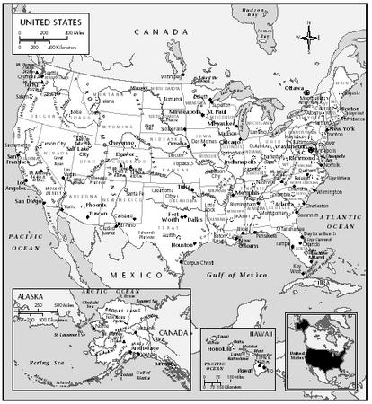
The United States of America, commonly called the United States (US, or USA, or America), consists of fifty states and a federal district. The 48 contiguous states and the federal district of Washington, D.C. are positioned in central North America between Canada and Mexico.
The state of Alaska is west of Canada and east of Russia across the Bering Strait, and the state of Hawaii is in the mid-North Pacific. The country also has five populated and nine unpopulated territories in the Pacific and the Caribbean.
At 3.79 million square miles (9.83 million km2) and with around 315 million people, the United States is the third-largest country by total area and the third-largest by both land area and population.
For extensive information on the geography and landforms of the USA (United States of America) please use this link.
US GEOGRAPHY:
For additional geography details please use the yellow navigation bar at the top of this page.
Alaska is America's largest state
Rhode Island is America's smallest state
California is America's largest state by population
Wyoming is America's smallest state by population
America's highest point is Mt. McKinley, Alaska
America's lowest point is Death Valley, California
US GEOGRAPHY NOTES:
Hawaii (not shown on the large map upper left) is approximately 2,550 miles southwest of Los Angeles in the middle of the North Pacific Ocean. Politically it is part of the United States in North America, but geographically, because of its (isolated location), is not considered part of any continent.
The Great Lakes, shared by the USA and Canada are a chain of 5 large freshwater lakes that form the largest lake group in the world, covering an area of 95,000 sq miles. Once vital to fur trading and regional development in the early history of both countries, the Great Lakes (in modern times) remain a significant transportation route for iron ore, steel, petroleum, grain, American automobiles, and much, much more.
Alaska (not shown on the large map upper left) is a state in the United States, situated in the northwest extremity of the North American continent, with the international boundary with Canada to the east, the Arctic Ocean to the north, and the Pacific Ocean to the west and south, with Russia further west across the Bering Strait. Alaska is the largest state in the United States by area, the 4th least populous and the least densely populated of the 50 United States.
MAP OF 50 STATES:
US OUTLINE MAP
print this map
An outline map version showing all 50 U.S. States is here
US MAJOR CITIES MAP
print this map
US TOPOGRAPHICAL MAP
print this map
This topographical relief map shows elevations and depressions representing mountains, hills and valleys by shades of color. This one displays color relief for the 48 states of the continental United States.
In general terms, the continental United States is dissected by a vast central plain (the Great Plains) from just west of the Great lakes, south to the Gulf of Mexico. The western third of the country is covered by the massive Rocky Mountain system and many other mountains ranges and hills.
In the east the much-lower Appalachian Mountains and its assorted ranges front a broad coastal plain that stretches from the far-northeast to the southern Texas coastline on the Gulf of Mexico.
That coastal plain of the southern and southeastern U.S extends to the continental shelf and is generally characterized by level (flat) land with assorted mixed forests. The coastal areas include bayous, deltas, marshes, mud flats and swamps.
US COUNTIES MAP
In the United States of America, a county is a political and geographic subdivision of a state, usually assigned some governmental authority. As of 2013, the USA (including Alaska and Hawaii) had 3,143.
Los Angeles County, California (9,962,789) is the largest by population; Loving County, Texas (82) is the smallest by population: San Bernadino County, County, California (20,057 sq mi) is the largest by size, and Kalawao County, Hawaii (12 sq mi) is the smallest by size.
Individual county maps for all U.S. State are here. A larger version of this map is here.
US INFORMATION:
Links to U.S. information pages that are updated daily.
US famous native sons and daughters
US facts and figures, capital cities and currency
US country flags
US land statistics, highest and lowest points
US landforms, lakes, mountains and rivers
US latitude, longitude and relative locations
US links to major attractions and points of interest
US maps, outline, political and topographical
US symbols, coat of arms and flags
US time zones and current times
US timeline of events and history
US travel information, airfares, cruises and train travel
US weather forecasts and current conditions